|
|
|
Story 9
The Kelly hut on Bullock Creek. (Kellys Ck)
Is this the Kelly hut that was at the sawmill site ?
by Bill Denheld
|
The latest
research indicates that the only known picture of the Kelly hut at Bullock Ck
was printed back to front.
A Kelly hut site was later built over by the McCashneys Sawmill during the 1930's.
Strong evidence now points to two huts having existed at Bullock creek
at the time the Kellys lived there.
The Kellys fixed up an existing hut and had built another at the creek that
was fortified with logs 2 foot in diameter.
Update Note; Since posting this report, during recent survey exercises
at Kellys Ck,
it was found the photograph of the Kelly hut below could only have
been photographed from the adjoining ridge slope to the
West of Kellys Creek, proving also the picture of the hut
was printed back to front when published as part of a series 'Views of
Kelly Country' ( collection of ANU ) OR, the picture is not of
Bullock Creek at all ??? The first thing to test is to see if a photo
like this could have been taken there as we are looking down on a hut
from an easterly direction looking west.
Here is the report,
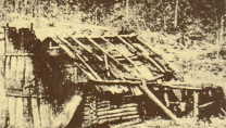 |
Photo of the Kelly hut. (on Bullock Ck)
Image source; ANU photo collection, part of the travelling Ned
Kelly Fact and Fiction Exhibition. Allegedly photographed by 'Stewart' of Bourke St Melbourne.
(Marian Matta)
|

|
left, The picture has been heavily cropped from a
larger panoramic view.
The original is being sought.
This picture has been reversed for the following reasons
explained. |
From written information reported in the Argus 26 Nov 1880
The chimney forms the greater part of the west end of the hut, The hut faces North as evident of the shadow details (and my conclusion), the door is on the north side opposite the gold workings, the creek flowing to the north.
According to Constable James's report to Superintendent Sadlier, the hut had no window, only a door. This fact was written Nov 1878, one month after the shootings at Stringybark Ck. If Cnst James said it had no window, I would tend to believe that.
He must have been referring to another hut.
The photo reveals:
1 The hut pictured is facing north. 2 Part of the chimney, end wall and roof are destroyed by fire-set supposedly by the Kelly gang when they left the hut for the last time. The fire did not take hold due
rain and wet wood. 3 There is a window and the front door is hidden by the large prop and wood shed in front of it. 4 The bush is cleared all round, consistent with the survey map of Kellys Ck featured in McMenomy's Book. 5 Log cabin style construction unusual for the Australian bush.
Allegedly built by a Canadian gold prospector (1860's-70's) During the
1877's, Dan and Jim Kelly fixed up the hut and began working the creek
for gold. ( Kenneally)
In a news paper report, Mansfield Courier Feb 10 1894, a
agriculture inspector Mr. Perkins makes a tour of the 130 odd farms of district to ascertain crop estimates under cultivation.
He writes of Mr. Stokes, whose property over looks Kelly camp,
-
"
his holding of 302 acres appears heavily timbered- 5 acres under cultivation. Dingoes are numerous; they destroyed his turkeys. Right opposite Mr. Stokes's door is the noted Kelly camp, where the huts stood; they are in a lane now. Just the remains of the foundations and fireplaces can be seen,
and the paddock of about 20 acres can be distinctly traced. There is a good road all the way from Mansfield to the spot now.
(Stokes's property was directly north of Kellys Ck
on the high side.
Source Sheila Hutchinson's Heritage and History on my doorstep.)
Note, to the above article, the author writes about huts in (plural) not singular. Does this mean there was more than one hut ? He also mentions fireplaces. (in plural)
We can be fairly certain of the spot where a hut had stood (as shown to me by Bill Stewart
during 1985). A sawmill was constructed directly over the spot around 1930.
Bill himself helped build the sawmill and he worked there during his 20's. If Bill Stewart said the sawmill was built over the Kelly hut site, then
this is so. He told me his dad had seen the corner posts there. Also reported
was that the chimney stones were moved away during construction of the mill.
(Sheila Hutchinson's book )
To get to the truth, we need to take into account all the bits of information available and piece it all together. Often, if a piece does not fit
'it' is discarded. It is not a matter of disbelief, rather we need to shuffle all the pieces till it starts to fit,- maybe with some gaps in between, but at least we are not discarding any pieces. That is what I am doing with this
story, shuffling all the pieces till we can make sense of it.
Let me take you on a geometric journey.
Following is a pictorial analysis of the hut photograph and it can tell us a lot about;
from where the photo was taken,
from what angle the camera was looking down,
how much higher the camera was above the floor of the hut, and how far the camera was away from the hut.
I'm no mathematician, but simple geometry can reveal all those considerations. Take for example where north was when the photo was taken. Pictured below, Line
S shows a shadow angle on the side wall of the hut
(under that log prop leaning against the hut) that shadow was
conclusively cast by the sun. Line O represents a theoretical horizontal line,
a level with the camera lens looking straight ahead. It is determined purely by the perspectives, yet accurate. The 7 is
height of the wall in feet, meaning the camera was 21 feet above the floor of the hut. The camera must have been situated on the nearby
hill ridge not far away to the west of the hut. To the east the ground falls away, so unless the photographer climbed a large tree to take this photo, which is unlikely, I conclude this view below is
now the correct way around. |
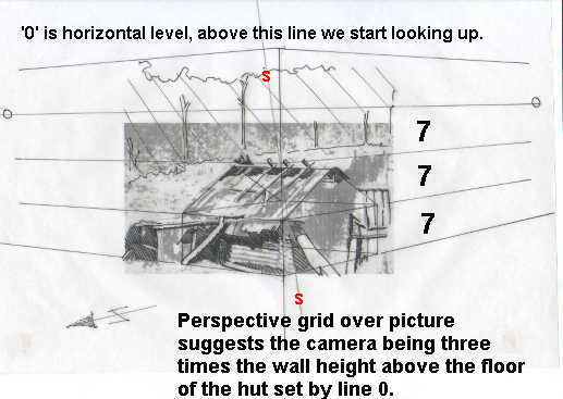
The 7 foot ( 2.13 m) has been calculated from information gleaned from the logs that make up the wall stack. There are 5 logs about 8 inches, and 9 logs at 6 inches. Even if we reduce the log diameters by 1 inch each ( which makes them skinny logs) we end up with a wall height of 80 inches, 6 foot 8 inches or 2 meters.
 |
|
The 'box' tracing over the hut pretty well shows the proportion of the floor plan as square. It was not large, 13x13 foot or 4 meters square. Another odd thing to note was the report that some of the logs of the fortified hut had logs up to' 2 foot thick'. No such logs are seen in this photograph of a hut.
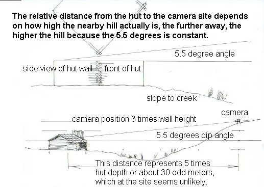
The above sketch shows the geometry of
both the camera elevation and the hut.
Update, recently it was proven that
the 5.5 degrees calculated can be achieved
only from the North Western slope that
overlooks looks Kellys Ck. This means the photo could
only have been taken
looking down on the hut from the hill
nearby, This does not explain the huge variations of descriptions recorded, nor explain how mature bullet holed gum trees were photographed at
around the
' Kelly camp' (see image below), yet this
camp was photographed only 5 years after
the ground was cleared by the Kellys during 1878. The gum trees photographed are estimated to be 50 cm in diameter suggesting they were at
least 100's of years old , and not short
term re growth ?
The evidence for two huts
The sawmill site ' hut site' may have been the
second hut as referred to by Mr. Perkins and reported in the Mansfield Courier 1894 because he says huts and fireplaces. It is unfortunate
Ned made no mention of two huts there.
My research reveals a most convincing
argument for 2 HUTS. This comes from G.
Wilson Hall's, ' Outlaws of the Wombat
Ranges' of 1879 and a report by a Mr. Perkins
of the agricultural department. G Wilson Hall states
on page 20-
” the gang prepared a log fortress,
victualled, properly loopholed and cleared
around of all shelter for besiegers, to
which they would make their retreat, and
sell their lives as dearly as possible.
( this must be the slab hut described by
Const James and located near the creek,
later the Sawmill site .)
Then on page 21 Hall states-
” They also
constructed a good log hut near the
site of their operations, which they
fitted up with the ordinary conveniences
of bush life, and carefully loopholed in
case of an attack”
( this was the existing cabin hut they
fixed up and was later photographed in the
middle of cleared land.
)
The agricultural inspector Mr
Perkins noted Mr Stoke's view over the
Kelly camp wrote- referring to the huts-
they are in a lane now. Just the remains of the foundations and
fireplaces can be seen,
and the paddock of about 20 acres can be
distinctly traced.
"They are in a
lane now"
gives us a vital clue. This suggests both
huts just happen to be situated along the
new lane which runs east - west.
I believe the original log cabin style hut
(built by a Canadian prospector) is
referred to by Hall as -
"They
also constructed a good log hut
" was in fact 100 yards from the
creek as plotted by the surveyor on the
survey map of 1884/5, and as
photographed in the clearing from the
ridge nearby). The other hut 'fortified'
referred to by Const James and Hall
-
”the gang prepared a log fortress"
, was built at their 'operations'
referring to both 'gold mining' and
'illicit whisky distillation' at the
creek? ( this meant in case of a siege
they had a close water supply)
The implication is this, - the description by
Const James does not match the only known
picture of a hut . James said the
fortified hut had no windows, was of slab
and log construction, both of which don't
fit the photo description. Who do we
believe, James or the picture?
we should believe in both.
But remember, the gang set fire to their
hut when they left the area but the fire
did not catch. Const James described a
fortified hut Nov 1878.
A picture of another hut appears in a
series of photos 'Views of Kelly country'
but it could well be this hut was not
at Bullock Ck at all ? Who would have
known ? There were many little cleared
farms in the bush with huts placed within?
However assuming there were two huts at
Bullock Creek, there is still a problem with dates. We
know the Kelly camp photo (below) was
taken before 1883 because that's when the
Ewan Tolmie died and the family left the
area for good. The only photo of a
complete hut was allegedly taken
around 1880 just after Ned was hanged. It
shows no hedge rows of wood stacked for
burning as described by Const James. So,
in the intervening years it is possible
fire destroyed the hedge rows and the log
cabin hut, leaving only the remains of the
fortified hut with bullock sculls and
stuff to be photographed by the Tolmie
work party just prior to 1883.
One interesting note I wish to make is that Bill Stewart
stated his father had said the four corner posts were still standing when Billy was still a small boy. If this log cabin hut stood at the sawmill site, '
there may NOT have been corner posts
in a cross over log cabin because log
cabins don't have corner posts? conclusion
or confusion ? as a child of six, Billy
may not have remember if the hut was here
or there, but he knew exactly where the
sawmill had stood because at 19 years of
age he helped build the sawmill at Kellys
Creek.
This amazingly photo (below) of the 'Kelly camp' was taken as one of a series by a riding party
that worked for Mr.Tolmie of Dueran Station. It shows what remains of the Kelly hut at that time
prior 1883. Note; a post still standing and a squared off timber on the ground. The bullock skulls were remnants left behind by the hut occupants and bones were numerous, it was written. You can see a close up of a bullet holed skull at story 10.
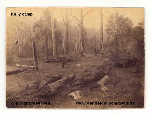
The photo although not dated, is thought to have been taken within a five year period after Kelly occupation. It may be the remains of the fortified hut of the gang as described by Const James, or maybe it was the log cabin hut as no corner posts are shown. If you were a photographer and wanting to show the remains of the famous Kelly hut, would you not try and photograph the corner posts?
It would appear the terrain is open enough to get a wide angle shot with the corner posts in situ,- if they were there? Bill Stewart told me four corner posts were still standing at the turn of the century (1900). |
|
I
do believe the Kelly hut as described by Const James,
was at this site above, this hut had no
windows, only one door, logs said to be 2 foot thick,
it may have had corner posts being slab
built, it had a steel plate door, had loop holes to shoot through
in all directions, but it may not be the hut shown below.
Notice the mature trees in close proximity
to the hut remains, yet in the picture
below it appears all trees close were
removed.?
|
|
This hut had a chimney that had caught fire, but this hut survived
due to rain. The ground was cleared all around consistent with
a survey map of 1884
(which
clearly shows a marked hut about 100 yards from the creek as ruined?) |
|
The sawmill and Kelly hut site is right on the southern bank of the creek, it certainly is
not 100 yards from it. If this was the hut marked on the map, then which hut was it that the Tolmie working party photographed shortly after the hut was destroyed? These are vexing questions.
Update 20 March
2005; For the first time in 100 years,
land allotment survey plans dated 1904
have been found which show the exact
location of the Kelly Hut on a road
reserve and a Kelly target tree that
served as a corner post of the block. This historic information came to
light only recently when historian Fay Johnson found the files at the public
records office. See Sheila
Hutchinson and Fay Johnson's web page
story Valid Links with the past click
here
With Global
Positioning System, GPS
accuracy we can now locate the sites on the ground. For all
those interested, on Saturday 19 March 05 Sheila Hutchinson and Bill
Denheld lead an
enthusiastic Mansfield Historical Society group on a tour to the sites and to check the hut
location according to the maps by GPS
co-ordinates. The result was found to be within 3 meters, and astonished
all.
The Kelly Hut on Bullocks Creek was first posted 18 July 2003
updated 13 March 2006
The Kelly Creek Kelly tree.
A large tree stood nearby which was used as target practice by the Kellys. It stood to the right of the above picture, and Bill Stewart told me it was standing when he worked at the sawmill in 1930's. It was known as the Kelly
target tree (at Kellys Ck). Bill showed me the remains of that tree lying rotting in the creek.
April 1985. ( It lay there till I
instigated its removal for preservation
Jan 2004. It was taken out thanks to
'Parks Victoria' and 'Bells' earth
moving contractors Mansfield )
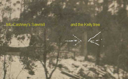
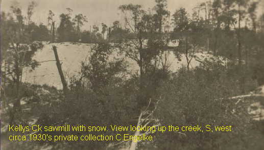
I wondered if there maybe a photo of the Mc.Cashneys sawmill around. Sheila Hutchinson told me she had a friend, Charlie Engelke in W.A. who's father had worked as engineer at the mill. Generously he sent me his photo collection and I found what I believe is a photo of the Kellys Creek sawmill with the Kelly tree nearby. This
was indeed an exceptionally lucky find.
This picture below is believed to show the Kelly tree at Kellys Creek.
Circa 1930's
Snow covered sawdust heaps was the reason
for the photo.
 |
|
|
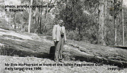
1956 This
log was the Kelly
Target tree after
it was dropped.
Most of the wood
was taken away for
either firewood or
furniture making
since it has
famous
connections. Bob
McPherson
pictured, although
co-incidentally having
the same name as
the title land
owner adjoining
the site, is
thought not to be
related. ( The
caption on the
reverse states he
was just a visitor
to the site,
however, the fact
his name did 'not
ring a bell with
caption writer
Harry Engelke', is
understandable as
McPherson's lived
on the adjoining
block some 50
years earlier.)

1985 Bill
Stewart left and
The Age newspaper
writer John Lahey
in September 1985
watching Alan
McMillan run the
detector over the
Kelly target tree.
Alan is standing
on the target tree
log now lying in
the creek. (
Unfortunately the
log is barely
visible in this
cropped print.)
Bill Stewart 81
told me ( some 6
months earlier at
the site ) that he
recalled how as a
six year old in
1909, his father
would take him and
visitors to the
Kelly camp and
pretend to cut
bullets from the
Kelly target tree.
The photograph was
taken by and
courtesy of Graeme
Stoney who was
co-owner of the
Mansfield Courier.
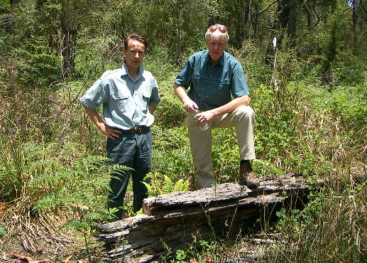
Dec 2003
Above; Pictured
left, Dept. of Sustainability&Environment historian Daniel Catrice and
myself at the Kelly target tree log. I had first seen the log as fully
round that you could stand high upon. It is now a mere shell, the remains
of a giant peppermint gum scared by eons of time, shot at, chopped at and
the tree even served as a subdivision survey marker, finally dropped down
for either firewood or curio during the forties. The unwanted end
lay rotting in the creek for sixty odd years and had become an
attraction for hundreds of visitors to the Kelly camp site on Kellys
Creek. Unfortunately, the fire prone site and fragile wood became
easy pickings to saw yielding Kelly enthusiasts.
With a direct
connection to the Kellys occupation and their friends predating the
Stringybark shootings of October 1878, the log had to be saved.
18 January 2004
Below, The
recovered remains of the Kelly target tree. At left, Mansfield Historical
Society historian Sheila Hutchinson, Kelly historian Dave White,
Kelly researchers Bruce Johnson and Nicole Jones, and at right
Joe Hutchinson.
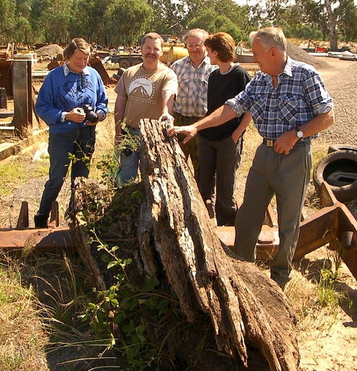
The Kelly target
tree remains will be preserved for eventual display at the new proposed
Ned Kelly Centre at Glenrowan. In the interim period it may be
displayed by the Mansfield Historical Society. Any suggestions
welcome.
All pictures shown with permission.
Copyright ,, no text or images may be reproduced without
written permission from the author Bill Denheld. Copyright
Contact bill at
denheldid dot com
direct for
feedback or
comment.
|
|
|
|