|
INTRODUCTION A PROBLEM TO SOLVE PUBLICATIONS TWO HUTS OVERVIEW STORY 1 The importance of the huts at Stringybark Creek STORY 2 One hut or two STORY 3 Orientation of the Burman photo STORY 4 How the bush hut fireplaces were found STORY 5 A Kelly Tree history STORY 6 McIntyre's sketch and the Burman photos compared STORY 7 BLUE RANGE, crucial to the Kelly story? STORY 8 The Bullets of Kellys Ck. My story 1985 STORY 9 The Kelly hut at Bullock Ck. Including the Kelly Ck Kelly tree STORY 10 The EK marked gun. Plus other Kelly items of interest. STORY 11 To be added - developments at Stringybark Creek 2009 LINKS CONTACT ME DIRECT  Bill Denheld,
|
|
|
TWO HUTS AT STRINGYBARK CREEK
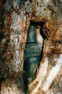
The fireplace could be that of the ‘shingle hut ‘that Ned Kelly and
Joe Byrne wrote about in their Jerilderie letter dated 1879.
Story 1
The
Importance of the Huts at Stringybark Creek
 Bill
Denheld
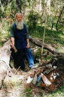
at the historic fireplace that he literally stumbled across while there with
renowned Kelly historian Gary Dean. All that remains of the fireplace is a
pile of rocks, roughly placed to form a three-sided structure with the open
side facing into a bush hut. The following week Bill found a second
fireplace close by. (Only twelve metres away). Few people alive today will
have set eyes on these fireplaces which predated
the police killings and the first map of the area by an estimated 10
-15 years. This fireplace (No1 found) could have been that of the ‘shingle hut ‘ that Ned
Kelly and Joe Byrne wrote about in their Jerilderie letter dated 1879.
Bill
Denheld
at the historic fireplace that he literally stumbled across while there with
renowned Kelly historian Gary Dean. All that remains of the fireplace is a
pile of rocks, roughly placed to form a three-sided structure with the open
side facing into a bush hut. The following week Bill found a second
fireplace close by. (Only twelve metres away). Few people alive today will
have set eyes on these fireplaces which predated
the police killings and the first map of the area by an estimated 10
-15 years. This fireplace (No1 found) could have been that of the ‘shingle hut ‘ that Ned
Kelly and Joe Byrne wrote about in their Jerilderie letter dated 1879.
I make this conclusion based on the fact that a drain depression around this hut indicates a level of care for the building, whereas the other hut location has no such feature. (Shingles are created by splitting straight grained logs into boards thicker on one edge and used in an overlapping fashion to cover the roof or walls).
We believe as reported, the huts were occupied by prospecting party, Reynolds, Bromfield and Lynch, who worked the creek for three months. My hypothesis suggest that Percy Bromfield had either built or re built a hut at this location or a ‘third’ nearby after one of the original two huts had caught fire during their occupancy. It is known Walter Lynch later set fire to Percy Bromfield’s new hut around July 1877.
This leaves only one original hut intact (and the remains of the other huts fireplace) either of which may have been of the shingle hut when the Kelly’s moved into the area at Bullock Ck. some eight months after Bromfield’s hut had been lost due to Lynch’s pyromania.
Kellys
reference to ‘The shingle hut’ refers to a ‘place’ where ‘huts’ had
existed for many years and it is only reasonable to suggest that one of the
huts was ‘shingle’ built as referred to by Kelly.
Speaking to
Mrs. Sheila Hutchinson who grew up in the Stringybark Ck area, it was
she who informed me about the Bromfield and Lynch’s debacle. She does not recall any
locals ever making mention of the two huts or of their fireplaces, and she has researched
and collected information for most of her adult life about the Wombat Ranges and can
point to locations in the bush where dwellings once stood.
It
would appear the rock fireplaces survived land clearing as they sit on a
small triangle of useless ground between the road and the creek - and a *snaky'
looking swamp backed by the steep ground to the south. An early wire fence
line detected on the ground indicates the huts were just outside a boundary
fence, - private land holding.
The hut fireplaces help to re-establish where the three police were killed by the Kellys’ in October 1878. The fireplaces are all that remain of the huts that were described as ruined at the time of the killings at Stringybark Ck. They have kept their secrets well and are difficult to find even if you know where to look. ( I say this because at the time of finding them the bush here was lush.
* Warning,
beware of snakes here and do not cross the creek except at a direct
crossing point near the Kelly tree.
Also beware of leeches.

Bill at first
fireplace No
1 not more than
The second fireplace reveals a
12 metres from the 2nd fireplace.
cooking pot lid and a penny coin 1885.
Were these the fireplaces of the huts that marked the location of the police
camp so clearly noted by G. Wilson Hall in 1879 and the surveyors in 1884?
G. Wilson Hall was the proprietor of the Mansfield Guardian. He circulated a pamphlet called ‘The Outlaws of the Wombat Ranges’ in 1879 and in this pamphlet he described the police camp as being near the ruins of two small huts. This pamphlet is rare with only three known to exist. It reads: (referring to the police camp),
“ The spot where they established their halt, was a small clearing on the rise alongside of the creek near the ruins of two small huts, one of which was burnt down and had been the temporary residence of three prospectors, Reynolds, Bromfield and Lynch who worked the creek for a short time with indifferent success” .
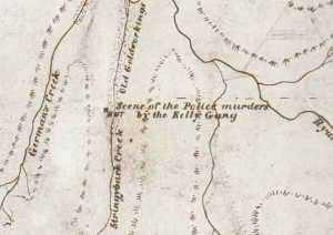 An 1884
survey map of the area marks the position of a lone hut on the opposite bank
to the "scene of the police murders by the Kelly Gang".
An 1884
survey map of the area marks the position of a lone hut on the opposite bank
to the "scene of the police murders by the Kelly Gang".
(see story 2, "One Hut Or Two")
Land Selection Files and Correspondence
Files: Public Record Office of Victoria (PROV) VPRS: 626/P Unit 650, File
19725/19.2
 |
 |
Above. The
Burman Photo showing a hut site by the two black posts I believe to be
Bromfield's hut. To support this, we know that Lynch had burnt down
Bromfield's hut some fifteen months before Burman took the photo. The above
sketch (right) of two huts on the western side of the creek shows them in
their relative position to each other.
Note, there is no way of knowing what the huts looked like other than for
hut 2 due to a lot of wire loops found in the sub soil there suggesting a
substantial bush hut whose frame had been tied up with wire. Items found
here suggests this hut No 2 survived the longest. It was also noted, of the
two huts, both were ruined and one had been burnt down.
We do not have a photo of the shingle hut, but
recently fellow QLD Kelly researcher Gregg Young alerted me to this
illustration below.
 Here we see an artists montage impression of a hut with the body of Lonigan
being taken out from the murder scene. Notice the hut has a fireplace to the
left with an open clearing to the front. Could this be one of the huts
standing when Ned said the police were camped at the Shingle hut- meaning
Stringybark Creek.
Here we see an artists montage impression of a hut with the body of Lonigan
being taken out from the murder scene. Notice the hut has a fireplace to the
left with an open clearing to the front. Could this be one of the huts
standing when Ned said the police were camped at the Shingle hut- meaning
Stringybark Creek.
Can we conclude that a shingle hut had taken more effort to build than
a bark hut and would have included a good fireplace. The fact that no
evidence of a fireplace has been found on the eastern bank of the creek
at the accepted site of the police camp ground suggests the shingle hut was
most likely one of the
fireplaces on the western bank.
We note the police
party had camped close to the blackened posts of a burnt down hut. McIntyre
said that when he identified the Burman photo postcard.
Regarding
the natural rock fireplaces, it is
likely that scarce materials like large rocks would have been recycled by
subsequent hut-builders and that they wouldn't be moved too far if at all,
from their original position. Therefore, it is fair to assume that the two
fireplaces
are in their original position.. Assuming that the bush hut fireplaces
mark the location of two huts, but how can we be sure they date
from that period?
A preliminary scan by a metal detector of the two hut sites revealed primitive ‘wire ties’ used to hold structural members together - consistent with the building of bush huts. Also found were an 1885 penny coin, remains of a muzzle-loading powder flask, ancient dark blue glass from bottles, hand forged spikes 6 inches long, horse stirrups and a horseshoe. All these items suggest that the huts date back to the appropriate period.
Items found at the fireplaces
with a metal detector.
 Most
items shown came from hut No 2. This indicates that the hut
built at fireplace No 2 could have been rebuilt by the time the surveyor
noted the hut on the 1884 map as he did not ‘note’ it as ruined. The
pick-holed BBQ grill plate was made from sheet iron tank plate, as we can
see a rolled top edge on a fragment. Next to the gun powder flask is a lead
centre out of a sandstone grinding wheel. Top, next to the horse shoe is a
foot stirrup and an old axe head wedge badly hammered on the head consistent
when splitting logs into shingles. (This wedge could certainly have been a
splitter for making a Shingle Hut). The wire loops are what held the hut
together and there is more wire behind the cast iron lid. The ‘Holbrook &
Co sauce bottle’ far left and the charcoal above the BBQ grill
came from fireplace 1.
Most
items shown came from hut No 2. This indicates that the hut
built at fireplace No 2 could have been rebuilt by the time the surveyor
noted the hut on the 1884 map as he did not ‘note’ it as ruined. The
pick-holed BBQ grill plate was made from sheet iron tank plate, as we can
see a rolled top edge on a fragment. Next to the gun powder flask is a lead
centre out of a sandstone grinding wheel. Top, next to the horse shoe is a
foot stirrup and an old axe head wedge badly hammered on the head consistent
when splitting logs into shingles. (This wedge could certainly have been a
splitter for making a Shingle Hut). The wire loops are what held the hut
together and there is more wire behind the cast iron lid. The ‘Holbrook &
Co sauce bottle’ far left and the charcoal above the BBQ grill
came from fireplace 1.
There is a possibility most of the items were brought here after 1884 and that one of the huts had been rebuilt several times. The creek could have been worked right through the two economic depression periods before and after world war one. However most of the items are consistent with the earliest times.
 |
 |
Above. The penny is badly corroded and I believe some of the
surface detail has been rubbed off when being cleaned to facilitate date
reading-1885. It was found within the bounds of the hut floor under 8 cm of
dirt.
Below, Gary Dean sits at the second historic fireplace with the rubbish dump in the
foreground. This hut site could have been of the ‘shingle hut’, although it
was larger than the other. Gary's extraordinary ability soon found the occupational ‘rubbish’ dump
hole beside hut No 2,
 |
 |
Above centre, An early Rosella tomato sauce bottle found near the bottom of
the dump has been dated around 1880’s, The light
orange colour looks like sauce, however it is more than
likely the long dead remains from bacteria.
Medicine and ‘Schnapps’ spirit bottles tell of merriment and health
problems at the camp. Shards of plates and crockery await to be analyzed.
Further archaeological digging may reveal even earlier dating circa 1860's.

These wire ties
are some loops of what held the hut together. More wire fragments are still
in the ground
at the site but these loops are still intact and have survived to tell the
story. Bush huts in those days were crudely built from what was readily
available.
 |
With nothing more than an axe, a hammer and some steel wedges, a roll of
fencing wire and perhaps a saw, a crude hut could be built in a week.
|
Even a
sheet of tin to line the fireplace would have been a luxury. It would have
to have been brought in on pack horse and would have been unlikely to be
used unless a more permanent dwelling was required. The walls and roof were
‘shingles’ or split logs with the bark from larger trees logs flattened out
to overlap the gaps . The roof is held down with saplings thrown on top and
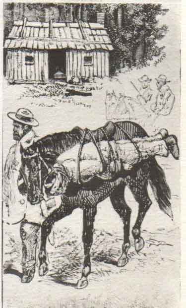
tied up with wire, as was the whole structure.

This hut at
Bullock Ck which had been occupied by the Kellys. This one was of log
cabin construction with crossed over logs on the corners and was not a shingle
built hut. Note the fireplace is made of rough wood that had
caught set fire
apparently when
the Kelly’s left the area after the shootings at Stringybark Creek.
________________________________________________
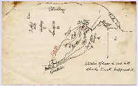
Using the 1884 survey map, Tom Bell decided to use the ‘hut plot' and scale from the map to locate the hut with a surveyors ‘chain’ measure, this brought him to near where the present day Kelly tree stands, but no evidence of a hut was found at this location.
|
|
|
Sketch of the huts in relationship to each
Detail of first map of the area 1884 survey. This was
other. I believe Hut 2 is marked on map. essentially a Gold fields map.
(right). Note I have the door on the end
Note, only one hut marked
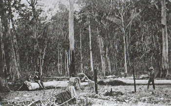
Gold had been discovered in Victoria 1851 and prospectors began to comb
every nook and cranny of the landscape. Almost every major creek and
watercourse was being sampled, mapped, named and recorded by mining wardens.
These maps became the basis for parish plans of the district. Among the thousands of creeks explored where gold was found, was Stringybark Creek deep in the Wombat Ranges and only accessible by pack horse.
In reference to the map (above), historian Ian Jones writes in the Ned Kelly Seminar Papers 1993: ‘the map remained stored at the central plans office of the Lands Department until Melbourne solicitor Mr. Tom Bell located the original 1884 survey map in 1970 ’ . From the 1884 survey map, a Melbourne lawyer 'Tom Bell' decided to use the ‘hut plot and scale’ information to calculate the distance from the junction of Stringybark Ck and Ryan's Ck to locate the hut with a surveyors ‘chain’ measure, (a chain was the old standard land measure of 66 feet). Working back up Stringybark Ck to where the hut was supposed to be found, this brought him to near where the present day Kelly tree stands, but no evidence of a hut was found at this location.
To be sure about the importance of hut or huts at Stringybark Ck near the police camp, the following is a reference made about two huts in the area:
In 1884 the surveyor preparing the first map of the district marked ‘Hut’ on the western bank of Stringybark Ck. and opposite the hut, he noted, ‘Scene of the Police murders by the Kelly Gang’.
The ’Argus’ news paper article dated Monday, October 28th 1878, just two days after the Killings, reported that ' the police camped from Friday evening at Stringybark on an open space on a creek - the site of some old diggings - and they pitched the tent near the ruins of two huts'.
The
Mansfield editor
G. Wilson Hall
tells us that
;
the
police camp was near the ruins of two small huts.
The huts, possibly re-built by prospectors Reynolds, Bromfield and Lynch perhaps
ten or fifteen years earlier were described as ruined when G. Wilson Hall
wrote about them in 1879. As Ian Jones pointed out, the surveyor was careful
to describe ruined huts as such, so the implication is that the ‘one’ hut
marked on the map on the western bank of Stringybark Creek was in reasonable
condition.
The fact that
G. Wilson Hall reported two ruined huts in 1879, with one having
been burnt down, is consistent with the surveyor noting one hut by
1884, It also means that at the time Burman took the photographs in
1878, he too must have seen a hut. The two
huts are on the West bank.

Hut #2 as
shown in the above illustration was more than likely standing at the time
when
Burman took his photo, but because it does not appear in the photo does not
mean it did not happen near the two huts, because the remaining hut could
have been burnt down just before Burman came along with his camera.
There are some historians who may want to explore alternative
scenarios as to which of the three hut sites was the Shingle hut. In
the above drawing I have
determined this to be hut #2 or maybe hut #1. If you
believe you have information to the contrary, I would invite your
explanation to be included here for all to read.
Ian Jones believes the two charred posts as the remains of the Shingle hut in his books.
But with the finding of the two fireplaces his books cannot be changed
even though he was well aware of the fireplaces 5 years before his 2008
editions.
In the intervening 5 years several historians have
questioned the viability of the east bank scenario. A group of five
Kelly historians have been working on Stringybark Creek investigation
initiated by Gary Dean and led by Bill Denheld with Linton Briggs, Kelvyn
Gill and Glen Standing. Follow this link
http://www.ironicon.com.au/stringybarkckinvestigation.htm
Please stay tuned for a comprehensive review considering all the facts to
the Stringybark Ck story, and the true site of Stringybark revealed.
Story
3
Orientation of the Burman Photo
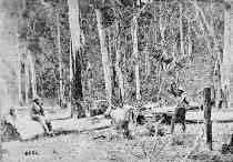
I observed that the main light
comes from the right, this means that the background details of the photo
are of the western bank of the creek.
The Burman
photos were taken as a record of the ‘murder’ scene.
Not knowing exactly from where the they were taken, were we looking north,
south east or west ?
Going by
the orientation of natural lighting on objects throughout the photo, I
observed that the main light comes from the right, indicating North. In our
Southern Hemisphere the Sun arcs through the Northern sky. Photographs in
1878 required long exposure times and we can guess the photographer chose
near midday to take the shots. In summary, from an analysis of natural
lighting we have been able to conclude that the camera was pointing South
West.
This means that the background details of the photo could be of the Eastern
or Western bank
of the creek.
A study of shadow details of natural light comes from the right hand side, indicating the midday sun arcing through our northern sky.
 |
|
Above: Note, the light on the boots, the twigs in the foreground, his hat, the log, light and dark, all indicate light from the right. This is not so evident in the main photo overall.
 Tracing
of shadow details over Burman photo (right) shows the angle of the light
leaning to the right of the picture. The enlarged detail, (above)
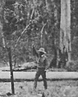
clearly shows the light coming from the right. The man sitting on the log
could very well be Mr Monk who lead the police back to the site a day later.
He could be seen sitting where Constable McIntyre sat with Ned Kelly behind
him. McIntyre survived the shootings and was not
present during the reconstruction. Looking at the boots, the hat, the log and
the faces, the light falls from the right. Although there was a clearing and a
big hole in the tree canopy
directing light in, even the figure with his arm raised has the light coming
from the right. Look at his shoulder: He is in the middle of the clearing,
yet the light comes from the right.
Tracing
of shadow details over Burman photo (right) shows the angle of the light
leaning to the right of the picture. The enlarged detail, (above)
clearly shows the light coming from the right. The man sitting on the log
could very well be Mr Monk who lead the police back to the site a day later.
He could be seen sitting where Constable McIntyre sat with Ned Kelly behind
him. McIntyre survived the shootings and was not
present during the reconstruction. Looking at the boots, the hat, the log and
the faces, the light falls from the right. Although there was a clearing and a
big hole in the tree canopy
directing light in, even the figure with his arm raised has the light coming
from the right. Look at his shoulder: He is in the middle of the clearing,
yet the light comes from the right.
The man behind the log represented Ned Kelly at the time when Sgt. Kennedy arrived back (the one with his raised arm), but it is doubtful Kennedy actually did this because according to documented evidence he dismounted, firing his revolver across the horse’s rump. Sergeant Kennedy after firing his revolver ran for cover and fired repeatedly at the Kellys, and during this initial shoot-out was seriously wounded. As he tried to get away, more shots were exchanged and he was chased and killed by Ned Kelly and his gang north east of Stringybark Creek at considerable distance.
Ian Jones
had concluded in his 1993 Ned Kelly books that the Sergeant was murdered at
Germans Creek because of horse tracks crossing the swamp north of the shoot
out site being on the East bank, but this has now been dismissed. The Police
had camped on the West bank at the Two Huts. The horse tracks quoted by
Jones comes from Constable James who followed tracks to Kelly camp over a
mile away. The horse tracks Const James followed were crossing the swamp
ground just north of the two huts site to the east bank, it was Kennedy's
horse ridden by Const McIntyre in his escape.
In Jones's seminar papers, that the Burman photographs were
taken looking south west. Apparently he had worked
this out from studying the two slightly different views that allow a 3D
perception of the background slope that seems to fall away to the left
(south). I do not differ from the Southerly orientation.
At the Stringybark Ck site Ian Jones matched up the Burman pictures with the actual area to tie in with a large flat area that fits with the pictures to complete the scene. However, while having no reason to doubt his conclusion, there was still no conclusive proof as to ‘from where’ the photographs were taken. I thought there may be some clues in the photos themselves that had been overlooked.
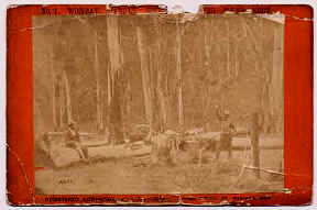 The original above. Enlargement right, Burman photo No2 far right |
 |
|
|
|
Story
4
How the Bush Hut Fireplaces were found
I thought there may be some clues in the photos themselves that had been overlooked. I noticed what looked like a fence, perhaps an indication of human activity-
The 1878 Burman photos of the police camp where the police were killed by the Kellys was used as evidence at Ned Kelly’s preliminary trial. Information gleaned from these photos led to the discovery of the two bush hut fireplaces.
Like others before me, I wanted to find the exact location of the police camp - after reading that it had eluded even the most serious of efforts to find. It had become a 65 year old mystery and I wondered if there was anything that had been overlooked. Referring to evidence in the photos, maps and written statements in books, Keith McMenomy’s ‘Ned Kelly, The Authentic Illustrated Story', and Ian Jones’s ‘Ned Kelly, A Short Life', and his story in the Ned Kelly seminar Papers, I wondered why the actual site could not be found considering that most of the jigsaw pieces were in place except one, a hut site.
I learn
that shortly after the shootings in 1878, the police department commissioned
Melbourne photographers ‘Burman and Madeley’** to take photographs of the
murder scene. Maybe ‘Burman and Madeley’ recognized a commercial
opportunity, as a series dozen postcard prints was later produced under
the title of ‘Kelly Country’.
 The enlargement detail left, shows what could be seen as a post and
rail fence on the slope, but in Burman photo 1 they are saplings
lying on the ground. It is entirely possible the long thin saplings may have
been axed and dropped by prospectors for building purposes as the area looks
as though it may have been cleared indicating human activity.
The enlargement detail left, shows what could be seen as a post and
rail fence on the slope, but in Burman photo 1 they are saplings
lying on the ground. It is entirely possible the long thin saplings may have
been axed and dropped by prospectors for building purposes as the area looks
as though it may have been cleared indicating human activity.
During August 2002, I contacted Gary Dean based at Glenrowan who has
the Ned Kelly website
website
www.nedkellysworld.com.au I
told Gary I was doing a story on Stringybark Ck and during our
correspondences I asked him what he could tell me about Walter Lynch and
reference to a Shingle Hut, as he had mentioned he had already mapped this
12 months earlier.
Gary said
he was prepared to show me this location and we arranged a meeting at
Stringybark Ck. I knew where his spot was and we would compare what we knew. Gary, my wife
Carla and myself crossed the creek, and together we walked to what we
believed was the true site of the
police camp on the east bank. Gary showed us where he considered the two blackened posts of a
hut in the Burman photo had stood. He
showed us some colour prints he had made of the exact scene as in the Burman photo
looking North East. I had a problem with this as I had previously sorted out the
orientation of the Burman photo via the shadows. I indicated to Gary that I thought his orientation was
incorrect as I considered that the Burman photo was looking South West.
(This scenario is totally dependant on knowing if the
Burman photo was printed the correct way around. Any photo negative can be
printed back to front. This story is reliant on the negative being printed
the correct way around.) See Story 3, Orientation of the Burman
Photo, and Story 6 The Burman Photo and McIntyre's sketch
compared.
I explained to Gary how I had arrived at this conclusion due to shadow details in the Burman photo
-
indicated North,- being the direction of the sun light coming from the right
hand side of the picture.
Secondly, I pointed out a detail in the back
ground of
the Burman photo that I considered looked like a small sapling fence - as well as an
indication of cleared ground with small timbers lying on the ground. Was
this looking South West from where we were standing?
To supplement this very scant information gleaned from photographs pointed out, we decided to immediately to take a closer look at the area of bush where I considered this activity may have taken place in the Burman photos. We had to cross over the swamp to the other side of the Creek and Gary went ahead as I had to carry some stuff back to the car.
By the time I could follow, he had disappeared into the bush well ahead when I called out to find him. He called back to say he had found it. I said what have you found. He replied “the fence”. As I approached in the direction of his voice (but I could not see him), I stumbled onto a pile of large moss covered rocks and said “Hey, Gary look at this”, Just then he came into view and we both looked at it and said: a fireplace. Gary then proceeded to show me where he had detected a fence which he said ran at an angle past the newly found fireplace, but I could not see this. On a return trip to the site a week later I found the second fireplace only 12 metres away.
 Left, Gary Dean, Bill and Carla Denheld at Stringybark Ck on the day we
found the fireplace of the hut No 1.
Left, Gary Dean, Bill and Carla Denheld at Stringybark Ck on the day we
found the fireplace of the hut No 1.
Below left, Gary Dean at fireplace of hut 2, with the rubbish
dump shown in the foreground. His shovel handle can be seen in the
rubbish pit hole he had dug out
Below right, Bill at the first fireplace of hut found.
|
|
|
________________________________________________
Story 5 The Kelly tree
and the
Police Memorial.
The ‘new’ Kelly tree was now the only link with the past, apparently
hundreds of metres
away from where the shootout actually happened and with the passing of generations of
local knowledge, the actual location faded into obscurity.
Perhaps one of the most famous trees in Australia, it attracts a lot of visitors and is accompanied by a fitting memorial to the three policemen who were killed here.
As early as 1940, Kelly historians had problems visualizing the present day Kelly tree in its surroundings on the western bank of Stringybark Creek as the site of the shoot-out. The picture of the Kelly tree (below), is looking south east with the Creek on the left. The iconic amour motif is being swallowed up by the marked tree until one day the motif will disappear altogether. With the true location of the police camp being confirmed by the finding of the fireplaces, one now wonders whether other plans for future tourism need to be made considering the key markers are some 300 metres from where they should be ?
If you can add to the story please send in your thoughts to-
bill at denheldid dot com
If you would like a site map please contact me with your name and address
and I will post one out to you. (Note, post only)
Side by side, the iconic symbols of tragedy.
 |
 |
 |
Above right. The Memorial stone at Stringybark Ck, dedicated to the three policemen, two of whom left families behind, a point that often gets ignored.
The plaque reads ; In Memory of Sergeant Michael Kennedy No:2009. Constable Michael Scanlon No: 2118. Constable Thomas Lonigan No: 2423. Killed at Stringybark Creek on the 26th October, 1878 during the execution of their duty in a gunfight with a group of men later known as the “ Kelly Gang “ Respectfully remembered and never forgotten The Victorian Police Force Plaque unveiled by Michael and Mick Kennedy on the 26th of October, 2001.
The
following is an extract from
‘Heritage
and History on My Doorstep’,
by
Sheila
Hutchinson
regarding
the Kelly tree.
Sheila, as a child lived nearby on an adjoining property to Stringybark Ck,
and her father Tim Brond had marked the existing Kelly tree during the
1930’s. In her book she writes,
April 25th
1908 ,
A Historical Tree. Last week a historical tree, known as the ‘Kelly’
tree, Toombullup, was cut down by employees of the Sawmill Company. Some
special timber was required and this tree being available, was cut
down.
A portion of it, measuring 26 ft. In length, was brought into Benalla last
Friday week for transshipment to Albury,
 Stump
of Kelly tree 1920’s
Stump
of Kelly tree 1920’s
Left, from J.J. Kenneally’s book published in 1929 shows the stump of
a tree from behind which it was written, that Kelly shot Kennedy. To the left of the stump
is a figure position of Kennedy when shot. Just which way this photo was
taken is unknown, Creek bank or road side?
Picture courtesy, Gary Dean
It should be noted that previously I
associated this stump picture above with the original Kelly tree.
Correction, the Kelly tree was north of the police camp and defined as the tree with
the bullet grazed marks on it near where Scanlan was killed. According to JJK,
Scanlan was some 30 yards from Kelly when shot, so we will never have a
photo of the original Kelly tree.
 Left, Stump of Kelly tree 1930’s
Looking at
the stump, it has been uprooted. Pictured, Harry Engelke who lived at
the top end at Stringybark Ck road from 1930 till 1950, poses besides the
stump remains looking (possibly) south east.
Left, Stump of Kelly tree 1930’s
Looking at
the stump, it has been uprooted. Pictured, Harry Engelke who lived at
the top end at Stringybark Ck road from 1930 till 1950, poses besides the
stump remains looking (possibly) south east.
Picture courtesy, Charlie Engelke.
WA
The old
stump believed to be that of the original Kelly tree, now only a reminder until a more convenient tree
was marked and close to the road. According to Harry's son Charlie, the stump was uprooted to make way for a
tramway track from the sawmill through this area ?
In the Seminar papers, Ian Jones indicates the Kelly tree was lost during the 1939 fires, although Sheila Hutchinson says no fires actually went through here at that time, but believes maybe a small clearing fire caught the stump prior to 1939.
For quite some time, through the 1930's depression and the war, there was probably not much interest in the Kelly saga. Eventually, years later, there was a revived interest, but by then everything had changed. There was still timber being cut and the scars of gold workings at the creek left its mark. In 1947 the land of the Tolmie tablelands was being acquired by the State Water Board and many land owners were forced off their land including those around Stringybark Ck. Eventual re-growth would take over from where wheat fields and potato farms had once been, this is true of the land on the eastern side of Stringybark Ck)
|
Kelly Tree Sept. 2002 looking South E |

|
Above right: Visiting Mr. Cuddon poses in front of a Kelly tree marked by land owner Charlie Beasley owner of the Stringybark Ck property. Photo looking North east, Courtesy C Engelke.
The very
straight tree trunk directly behind him is inscribed 1878 ( text
Lonigan shot by the Kellys ).
The sign was facing the road so visitors did not have to venture onto
the private property. It was on the eastern side of the road looking to
the creek. I was informed by Charlie Engelke this tree was dead
and soon after rotted and fell over. The next and
present day Kelly tree can be seen in the background behind Mr. Cuddon to the left of the
picture. It is slightly obscured by a sapling. It is a forked tree later to become the present
day Kelly tree.
Sheila Hutchinson tells us that her father ‘Tim Brond’ scarfed the present
day Kelly tree between 1933/4 and carved the names of the three policemen
deep into the wood. ( bottom left )
 Kelly tree 1960, S.Hutchinson |
 1985 Authors's picture |

|
The ‘new’ Kelly tree was now the only link with the past. It provided the marker to curious visitors to indicate where the famous gun battle had occurred. The only problem was, it was on the wrong side of the Creek and hundreds of metres away from where it actually happened! With the original trees loss, and with the passing of generations of local knowledge, the actual location faded into obscurity.
Even though there are display amenities at Stringybark Ck, I wondered for
how many more years visitors would come here only to be faced with the
deception of a Kelly tree that was hundreds of metres away from where it
actually happened!
I
felt compelled to try and solve the mystery and find the correct location of
the police camp and the Kelly tree, not expecting to find the shingle hut
site as well.
________________________________________________
Story
6
McIntyre's sketch and the Burman Photographs Compared
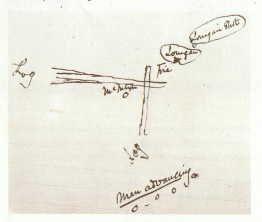
The magistrate was shown a ‘post card’ of the police murder scene, (not a photo, but a ‘post card’)
When we compare this sketch with the picture of the police camp, we can see they don’t exactly match. You would think that crucial information like this would have been well examined before it was submitted at a murder trial’ .
 McIntyre's
sketch
McIntyre's
sketch
Text reads,
Lonigan shot,
Lonigan,
Fire,
Log,
McIntyre,
Log,
Men advancing.
(The dot on
the left was Ned Kelly. They came from the south.)
Sketch and Post card below
reproduced with the permission of the Keeper of Public Records. Public
Record Office
Victoria, Australia'. Burman
Photo1, citation No, VPRS 4966 Consignment P0 Unit 2 Item 30 Record 1 Document: Photo of Wombat Ranges where troopers were shot.
This sketch drawn by Constable McIntyre, the only surviving witness to the shoot-out, was to show where Constable Lonigan was killed in relationship to the camp fire, the arrangement of large tree logs and the position from where the gang advanced. Apparently Constable McIntyre had made a written statement accompanied by this sketch.
When we compare this sketch and the photo by Burman of the police camp re-enactments, we can see they don’t exactly match.
In order to compare the sketch with the photo we need to turn the sketch around so both pictures are looking south. In the sketch south is up and the logs form a ‘Vee’ quite different than in the Burman photo.
 |
|
With the sketch upside down, you will see the four dots representing the four men advancing ( the Kelly Gang) are now on the left hand - upper side. McIntyre said the men advanced from the South side which is from behind the seated figure on the left of the photo. The sketch is now aligned with the photo.
Obviously a
photo does not lie, but in the sketch, the logs lay the wrong way if they
represent the two main logs of the photo. Did McIntyre get his North and
South mixed up? Or was the sketch drawn from memory only? It is probably
unfair criticism to suggest McIntyre could not draw, however, you would
think that crucial information like this would have been well examined
before it was submitted at a murder trial.
However, McIntyre did give a detailed description of the police camp some
years later, try and follow this - it reads;-
(my
comments are in blue)
" Srgnt
KENNEDY had selected a clear place near an old burnt hut as the
most suitable for our camping ground as it was out of danger of any timber
which might fall from the forest trees. Our tent was pitched near the
north west corner of this clearing which was partly
natural and partly caused by human agency.
|
|
It is his
reference to north west corner that may indicate the Burman photos are
printed the wrong way around because we can work out where north is in the
photo.
See Orientation of the Burman Photo story 3 (North is from the right using the sun in our northern sky during mid morning to afternoon sun) |
"The entrance to the tent was facing east and also the
creek which was about 70 yards distant."
I believe this view is basically looking South West. The tents location
would have been to the Far Right of the tree right directly behind the man
with raised arm. The creek about 70 yards distant from the tent in this shot, it would
be to the very left of the seated figure.
This issue presents the belief the camp was on the western bank of the
creek: and Was the police camp on the Eastern bank of the creek at
all ???
 |
With the image reversed, Northerly is now from the left. The tent would now be located at the North east corner of the clearing and the view is now looking East -SE, but the creek would now be directly behind the seated figure. |
McIntyre said, "
Standing at the tent entrance and facing the creek -
indicates
the tent was on the western bank of the creek looking east because he says
'facing the creek' ? The camp must have been on the western
bank of the creek.
The remainder of his text now makes more sense, except the photo is reversed.
The reversed photo scenario is not to be accepted if the following
description are to be taken as fact.
- "
there was upon the left front
a felled tree nearly 4 feet in diameter, at the thickest part. It lay
nearly east and west.
( This gives us
an orientation for the Burman photo) About midway this log was joined by
another which lay due north and south and terminated where it joined the
other. These two logs thus formed two right angles, the point of the
junction being about 25 yards from the tent. On your
right or the south side of the clearing the ground was
free of timber and being of a swampy nature there was a
luxuriant growth of rushes and other course herbage. These together with a
slight declivity in the formation in that direction afforded good cover
to within 20 yards of our tent for any party wishing to
attack our camp and it was from this position we were attacked,
the south side or up the creek; while Kelly's hut was to the
north of our camp and in the direction the men had gone on patrol."
For an east bank scenario, to read the above
orientation very carefully, one can conclude it is the exact opposite to our
orientation as depicted in this, Twohuts scenario.
However, the above McIntyre description is worthy of wider study.
Accepting that the Burman photos are not printed the wrong way around, you will find my
orientation fits the overall scenario best.
If the above McIntyre description does not fit reality in the
field we may need to question if the Burman photos were flipped over?. There are three key exhibit pieces,
(1) is
McIntyre's sketch which has readable text, so it is the right way around.
The other two are the Burman photos, a sketch by "Illustrated
Australian NEWS" front cover depicting the police camp of 28 Nov. 1878, and
the Australasian Sketcher which shows spear grasses to the right of the
Burman photo logs.
Picture of 16 Nov 1878 Sydney Mail drawn from McIntyre's first hand sketch

Notice the tent left, the gang shooting to the
north, the creek swamp foreground- all points to this view shows the west
bank looking westerly.
Image courtesy, Qld State Library,
Sydney Morning Herald, 28 Nov 1878
 |
In this scenario
the "Illustrated Australian News" is seen as incorrectly orientated with the
Burman photos if CORRECTLY printed, however it again
may prove to be printed the other way around, but the Burman photos would be
flipped to fit McIntyre's description. |
Shortly before his execution, Ned Kelly wrote a letter to the Governor of Victoria hoping to point out the injustices of his case. In it he asks the Governor to examine contradictions in McIntyre’s evidence, suggesting the governor would at once see the disparity between the two versions, and using the Burman photos and a 'postcard' Ned hopes to verify that they (the gang) were in a direct line when facing the two police at the camp - proving they did not ambush the returning police. In his defense he told the court the men advanced from the spear grasses behind the seated figure at the south side of the open ground.
At the
trial, there must have been doubts as to the usefulness of the photos and
the sketch. McIntyre had already testified that his sketch supported his
written statements some 21 months before. It is hard to believe he would
have made such fundamental errors. Maybe he could not remember all the finer
details. The fact that the logs are lying at different angles could be the
result of possible guess work, but omissions from the sketch include a
remarkable number of vital bits of information. Such as: 1 - the
location of the police tent (which was burnt down by the Kellys), 2
- an indication of North, and 3 - the two blackened posts of a burnt
out hut. These omissions only help to confuse rather than inform. Thus, when
the Magistrate is shown the sketch and photos of the same place, it is no
wonder he writes a little note attached to the photograph as follows,
“ Doubts as to the accuracy of the scene ( leading to reconstructions
) perhaps been stimulated by a sense that this is a fairly unusual piece of
evidence to Introduce”.
(the
note is still attached to the photo and kept at the Public Records Office of
Victoria archives)
The statement suggests that there was some confusion in assessing the evidence. The magistrate was shown a ‘post card’ of the police murder scene, not a photo, but a ‘post card’. Secondly, the magistrate compared the sketch by Cnst. McIntyre with the ‘post card’, and as can be seen in the previous pictures, they are quite different.
 |
This tracing taken from over the Burman photo help establish a grid on the ground. This reduced size image does not do the grid justice for what it reveals.
Using all
detailed information from the Burman photos,
a reasonable picture of the configuration of the logs can be reconstructed.
First, a grid was created on the ground using the two blackened posts and
the edges of where the hut had stood. The grid was calculated at about 10
foot or 3 metres and aligned with the corner of a burnt down hut. A tracing
over the photo allows the angles of the logs to be plotted on the grid.
We are looking at an triangular area no bigger than a
triangle 60 foot by 60 foot
or 18 x18 metres.
Below. A birds eye view of the grid shows the logs lying in their relative
place to each other.
This drawing was created entirely from the Burman photo information.
|
Notes 4
East west
Log. Stump where Lonigan was shot. 11 Log partly seen in
both photos. 4? What looks like the end of a log in one photo is
not in the other ? 8 Kelly brothers Ned (right) and Dan with two
friends advance into the police camp from the south through tall
spear grasses. 13 Position of Constable McIntyre sitting on log with Ned Kelly crouched behind Mc when the two mounted police returned to the camp, but only for the photo re enactment as Mc actually sat on log 4 with Ned behind fire9. 14 Sergeant Kennedy re-enactment for the photo, did not approach this way, he dismounted from his horse and fired over his horses rump. 5 Site of a burnt out hut marked by the charred posts and mounds of earth along its walls.Note Photographer’s glass plate case. Photo1 and Photo 2 camera position of Burman photos View angles looking south west. 13 log that crossed log4. The tent was to the right of logs 4 and 11.  |
Grid is based on distance between the two charred posts plus two feet = 10 feet. This was calculated from the figure (14 ) being of average height and projecting the perspectives on the ground to establish a scale.
The above
birds eye view illustrates how the logs were laying from photographic
evidence. In conclusion, I believe McIntyre drew what he remembered. Maybe
he never did return to the site, otherwise he would have drawn a more
detailed map. However, compare his sketch again with my sketch and a
similarity appears.
McIntyre’s sketch upside down My sketch based on
Burman photo details
|
|
 |
In my sketch ( above right) McIntyre’s logs could be No 4 and 11, whereas everybody considers them to be No 13 and 4.
This picture below (right) was published in Illustrated Australian NEWS on 28 Nov. 1878. It is an artists view looking back at the tent with the two small blackened posts in front. During intervening years since this research was first started we could not work out whether the artist got this view right. We now believe it is correct as the view is looking westerly with the creek directly behind us and the crouching figure.
 |
|
Notes, In some publications the figure with raised arm was supposed to be Kennedy on his return to the camp after surrender (which he did not do), but in this picture the figure represents McIntyre. The illustration was drawn and published just one month after the event. The raised arm figure is in the exact same pose as in the Burman photo except flipped over by the artist, which suggests that he had a copy of Burman’s photo to go by.
The artist
drew two logs crossed as in McIntyre’s sketch indicating the artist also had a copy
of his McIntyre's sketch. Just in front of the tent are
two small posts of a burnt out hut seen in the Burman photo but these posts
were actually to the right of the horse. The
orientation of the published picture of1878 has the tent on the left of the
action, which is consistant with what McIntyre wrote, the tent was in the
North West cormer of the clearing.
I make no apology for the long winded explanations in telling this story.
Bill Denheld Oct 2002 amended 14 March 2006 and May 2009
and 2012
________________________________________________
Story 7 Blue
Range,
Crucial to
the Kelly Story !
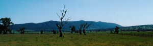 Blue
Range
as seen when leaving Mansfield on the way to Tolmie and Stringybark Ck.
Blue
Range
as seen when leaving Mansfield on the way to Tolmie and Stringybark Ck.
It may be that Blue Range played a crucial role as to why the police went to
Stringybark creek due to a letter received at police headquarters. This
little known fact has been overlooked by many.
 |
 |
 Reproduced with the permission of the Keeper of Public Records. Public Record Office Victoria, Australia'. Citation No, VPRS 4969 Consignment P0 Unit 2 Item 72 Record 1 Document: Discovery of cave near Murchison possible Kelly hide-out, and Map of Cave. |
A plausible explanation hinges on the above letter and map sent to the police dated 18th Oct. 1878, by a writer who asks to remain anonymous. The letter dated just 8 days before the police shoot-out with the Kellys, advised that a cave situated at Blue Range could be occupied by the Kellys.
To find this cave, the writer gave instructions to draw a straight line between Stringybark Ck on the east and Euroa in the west, and the cave would be found where the line intersected Blue Range. This means we now know more than likely where two of the police party went on that first and fatal day.
The letter and map sketch are quite possibly the reason why the police party used Stringybark Ck as a staging post for the pursuit of the Kellys.
The letter reads;
To, Inspector Nicolson, Police Department Melbourne Private
[Tarringilo?] Murchison 18th Oct. 1878
Sir
As the information may be of relevance and is not known to the Police, I beg
to inform you that directly on the line of Country between String Bark Creek
and Euroa on the Blue Range near the Hills Hole Diggings there is a "cave"
which such
persons as the "Kellys"
might stay for years if they had provisions supplied without the fear of
ever being found out except by accident I will try to describe the place as
well as I can & perhaps it might be worth while for the Police to pay this
place a visit. Of course you will keep my name out of any instructions you
may give as if by any chance these fellows friends knew it would be easy to
burn my establishment out. I hear that there are a good many of there
relations near here farming, So I will rely on this being perfectly private.
The spur I mean is at the head of the Glen Creek on the "Junction Station"
and is close to the "Gap" in the Blue Ranges going over to "Baryang" By
running up the "Tangalooke" Creek, past Hills Hole and keeping all the Creek
on the N. W. until the Gap looking over to the Glen Creek is reached, then
keeping to top of the Range, until the first - spur is reached leading
towards Glen Creek and on the top of this spur which is abrupt at the point
the "Cave" [missing] I can ? about 20 or 30 yards [missing], I have been in
it once 20 yards and it presents the appearance of an "extinct Volcano"
There are some very high rocks just above it I will try to draw the
situation but don't say I will succeed I hope this information may be of
secrecy and that you may have the honor of stopping these fellows foul
careers.
Believe me
Yours faithfully
(signature unreadable but likely Winter )
Note: There is no evidence the Kellys ever inhabited the
cave.
UPDATE: This cave has been found
pretty well as described and visited by Stephan and Mellisa Hanbury
and mates David and Debbie Hibbert, 27 July 2014
![]() fs-267_Kelly_Cave.pdf
fs-267_Kelly_Cave.pdf
Below, a recent aerial view of Stringybark and Kellys Creek.
 The
gully below the wing strut is Stringybark Ck (left) and at centre right is
Kellys Ck. The horizontal ridge along the middle goes down to Ryan's Ck
dipping away from the viewer.This
view shows the relative distances between Stringybark Ck and Kellys Ck,
about 1.6 km and to the foot of the Southern end of Blue Range shown at the
uppermost edge is about 12 km away. An easy ride for the two mounted police
camped at Stringybark Ck.
This view is looking S. West
The
gully below the wing strut is Stringybark Ck (left) and at centre right is
Kellys Ck. The horizontal ridge along the middle goes down to Ryan's Ck
dipping away from the viewer.This
view shows the relative distances between Stringybark Ck and Kellys Ck,
about 1.6 km and to the foot of the Southern end of Blue Range shown at the
uppermost edge is about 12 km away. An easy ride for the two mounted police
camped at Stringybark Ck.
This view is looking S. West
The fact that the police set up camp at Stringybark Ck on Friday 25 Oct. 1878 makes one believe the police took note of the letter, although the writer does not suggest making Stringybark Ck their base camp there. However, the police did receive the letter and it appears they acted upon it. ***( see notes)
Note that this supposition appears to be torpedoed by the transcript of the Royal Commission into the events relating to the uprising after Ned Kelly’s execution. In the transcript, letters from Supt. Sadleir to Sgt. Kennedy mention Stringybark Ck as a suitable place for the police camp, # (see notes). These letters predate the police expedition by some two months, and on the surface, are probably the prior initiation for their destination.
In any event on 21 October three days after the Blue Range letter was written, Superintendent John Sadleir issues instructions for the police party to prepare to set out. We cannot know whether the Blue Range letter was received in time. If it was, then it would have served to confirm their plans and provide the Blue Range destination for the Saturday search by Kennedy and Scanlan.
It is curious that the Blue Range letter was not included in the voluminous evidence assembled for the Royal Commission in 1881. In fact its existence was little known to Kelly historians until just recently when I came across it in the Ned on Line web site compiled by the Public Records Office PROV. this year 2002.
Whether the reference to Stringybark Ck in the Blue Range letter was coincidental to their (police) plans is unclear, however the Royal Commission did not come about until some two years later and it could be possible that in the earlier police letters, the mention of Stringybark Creek helped to protect the hopeful anonymous writer. (Hopeful because there was a reward posted for the capture of the Kellys).
With a reward of One Hundred Pounds for each of the Kelly brother’s capture, posted at the time ( April 1878 ), one wonders whether the Blue Range letter was shoved to the bottom of the drawer. My supposition is, they, Kennedy and Scanlon went to Blue Range in the hope of catching the Kellys there themselves, and if possible claim the reward. This may explain why the Blue Range letter seems not to have been noticed till just recently. *** (See notes)
Also, in the earlier letter, (Kennedy to Sadleir), Sgnt Kennedy had confidently suggested he and Cnst Scanlan could mount a successful arrest with the help of two additional officers. One chosen for his ability to identify the Kellys the other for his knowledge of the country. Neither were asked to take part on the first day excursion.
All the police were dressed in civilian clothes as if prospectors. Sgnt Kennedy and Cnst. Scanlan had benefited from a previous arrest ‘reward’ and were mates.
Exactly how the Kellys learned the presence of the police in the area remains unclear although the 'bush telegraph' worked very well throughout their time on the run. Ned wrote in his ‘Jerilderie letter’ in 1879, I came on Police tracks between Table Top and the bogs. I crossed them - .He was also aware of two police parties out looking for them. - as I knew the other party of police would soon join them and if they came on us at our camp they would shoot us down like dogs-.
Here is an extract from the ‘Jerilderie letter’ Ned Kelly’s words, it reads ;
I was not there long and on 25 October I came on Police tracks between Table Top and the bogs. I crossed them and returning in the evening I came on a different lot of tracks making for the shingle hut I went to our camp and told my brother and his two mates me and my brother went and found their camp at the shingle hut about a mile from my brothers house we saw they carried long fire arms and we knew our doom was sealed if we could not beat those before the others would come as I knew the other party of police would soon join them and if they came on us at our camp they would shoot us down like dogs at our work as we only had two guns. We thought it best to try and bail those two up take their firearms and ammunitions and horses and we could stand a chance with the rest.
Reproduced courtesy of The State Library of Victoria.
Other
reasons offered why the police came to the area came from Ned Kelly himself. At his preliminary Beechworth trial, he blamed a boundary rider and 'wild dog' poisoner, John Martin*, who worked
for a local landowner Mr. Tolmie. Martin had blazed a trail and laid baits
close to the Kelly camp on Bullock Creek, and Dan Kelly had discovered the
evidence shortly before the police set out. After the gun fight at
Stringybark Creek, a Constable James and black trackers followed the blazed trail into the
Kelly camp, but this was about one month later.
At the Kelly camp a nearby tree had been marked J.Martain, thought to be seen to spotlight the person responsible for the Kelly's demise. Was 'Martain' meant to be Martin. It is interesting to note that Martin would probably not miss-spell his own name if he had carved it in, indicating the Kellys may have done so. This could be supported by the fact that in the Jerilderie letter, Ned or Joe have spelt another person with the same name of Martin, as ' Martain'.
Suggesting it was carved by by Ned Kelly himself.
Note;
According to the Royal Commission report, Mr. Tolmie showed Sgnt, Kennedy
the camp site at Stringybark Ck himself, so it is unlikely Martin had
anything to do with the police coming to Stringybark Ck. ***(see notes)
(This John Martin was most likely a son of pioneer John Martin who held
Howqua Station lease from 1848. This needs to be confirmed)
Mansfield Guardian dated 16 Nov 1878 reported that 'Walter Lynch was with the Kelly party the night before the police were murdered and could give information as to who the unknown men are who are with the Kellys'.
(source,Sheila Hutchinson)
With the implication, of Lynch having intimate knowledge of the Kellys' at their Bullock Ck camp
hideout, we may wonder whether his former partners Bromfield or Reynolds also held that knowledge?.
In search for reasons why the
the police decided to camp at Stringybark Ck instead of anywhere else
(within the thousands of square miles of the Wombat Ranges), we should ask the
question, ' did Percy Bromfield , Willy Reynolds, Walter Lynch, John Martin
or a Mr. Tolmie' or any one of those men notify the police of the Kelly's being at Bullock Ck.
Then, consider the Blue Range letter being sent only a week before the police
set out and in it suggesting the Kellys could be at
Blue Range not far from Stringybark Creek.
Sergeant Kennedy (in charge of police station Mansfield) having an
optimistic view of quick capture, together with the lure of a very
generous
reward offered to the police as well as members of the the public, the attempted capture of the
wanted Kellys began.
The police party of four left Mansfield early one morning to reach
Stringybark Ck the next morning the 25th October. Their journey can be
traced by McIntyre's description in his memoirs.
"The
Manuscript of Thomas McIntyre -The sole survivor of the Massacre of Police
at Stringybark Creek."
 There
are two versions of the route the police took, one from McIntyre himself,
the other from Ned Kelly.
There
are two versions of the route the police took, one from McIntyre himself,
the other from Ned Kelly.
Ned's version suggests
the police party got lost, as they ended up near at the headwaters of
Ryans Ck and worked their way back west along it till they found Stringybark
Creek and shingle hut on Stringybark Creek.
To see the map and story of the journey they took
click here.
At the Ned Kelly Seminar in Nov. 1993, Ian Jones was asked by a member of the audience (Glenn Davis) whether there was any substance to the suggestion of Sergeant Kennedy and Cnst. Scanlan having been tipped off about the Kellys being at Bullock Ck. In his reply, Ian Jones stated, ‘ it is totally illogical that Kennedy and Scanlan knew they were so close.’ *** (see notes)
In essence, ( as reported by Ian), ' when the police party arrived at Stringybark Ck on the 25th. Oct. 1878 they had their first meal (probably pre prepared): ham and sweet cakes. Everyone agreed it was an awful meal. and Sgnt Kennedy suggested McIntyre try shoot a kangaroo that night for their next meal. He was unsuccessful as no kangaroo was seen. The next day while the other two were out on patrol, McIntyre tried again without luck and apparently in frustration he did shoot at some parrots.
That shot was heard by the Kellys only one mile away and they had to investigate. One asks the poignant question, did their first lousy meal lead to the shootout with the Kelly gang ?
Another interesting consideration regarding the Blue Range letter. The letter, it appears may have brought the police to the area. Had it been written ‘that a line be drawn’ between Bullock Ck instead of Stringybark Ck in the East and Euroa in the West, for finding the ‘cave’, then the police would have hit the bulls-eye with the Kellys living at Bullock Ck, that would have surprised the police even more than the Kellys!
Bullock Creek (later renamed Kellys Creek) was the site where the two wanted Kelly brothers managed to evade police for 6 months for the so called 'attempted murder' of Constable Fitzpatrick in April 1878. Time was running out for them as a well armed police party had set up camp at Stringybark Ck. on 25th Oct. 1878.
The Kellys were confronted with a decision that would change their lives. The plain clothes police dressed as prospectors and possibly acting more in their own interests to claim a reward may not have realised how close they were when Constable McIntyre fired shots at some parrots. Those shots were heard at the Kelly camp. Ned Kelly knew the time had come, their hideout would be discovered, their weapons would be no match, and they were done for. To survive they would have to take the initiative - take the police camp by surprise and order them to bail up, capture their guns, horses and provisions and clear out.
Unfortunately things did not work out as Kelly had hoped, and the police (except McIntyre) didn't surrender. Instead they drew their weapons and engaged in a fatal gun fight. Questions as to whether the Kellys acted in self defense has been the subject of debate ever since.
The whole Kelly gang saga was remarkable as it captivated National newspaper readers who were fed headline editorials and illustrated pictorials. It was the age of the camera and photographers eagerly captured the action right to the end.
Killings or Murders
The terrible events at Stringybark Ck on 26th Oct.1878 began one of the most intense bush ranger hunts the colony had seen. The Kelly gang, as they became known, managed to evade all efforts by the authorities to capture them for 20 months. The hunt ended at Glenrowan on 28th June 1880, which saw three gang members dead and Edward Kelly tried and hanged on 11 Nov. 1880.
Even today, the intrigue and fascination of the Kelly Gang’s exploits so long ago still grows and is increasingly attracting world attention - while remaining baffling to some, however, one thing is for sure of Ned Kelly, of him it was said ;
‘ He is at present the only national hero who has
become
mythical. He
will gradually become a Robin Hood I expect.’
This was
written in 1889
by Charles
P. Trevelyan in his ‘ Letters from North America and the
Pacific,
Source, Brian McDonald’s Kellyana, A Bibliographical look at the Ned
Kelly Legend.
More items
on Stringybark Ck to follow.
The true location of the shoot-out at Stringybark Ck. revealed on site map. Location maps are being prepared subject to overall planning for the area by the appropriate authorities.
Notes
The name Scanlan is often spelt Scanlon. Most official documents have Scanlan including, his grave headstone, monument Mansfield town centre, The Royal Commission of 1881, J.J. Kenneally' s book of 1929 and his records in court cases of the time. Scanlon is recorded on the memorial at the Stringybark Ck reserve, in books, by Ian Jones, Keith McMenomy, Max Brown, Gary Dean and G. Wilson Hall to name a few. In this website I chose Scanlan.
* According
to Public Records Office of Vic (PROV) Burman and Madeley was the company of
photographers based on Bourke Street Melbourne. The Mansfield Guardian dated
28 Nov.1878 refers to Mr. Burman as selling the photos as advertised (
Sheila Hutchinson’s book, Heritage and History on My Doorstep)
** Apart from burning down Bromfield’s hut , Walter Lynch was a Kelly
sympathizer who had occupied the huts prior to the events there and wrote a
threatening letter to a local Mr. Monk who apparently helped the police.
Later, Lynch was prosecuted for his threats and served three years in gaol.
Note; Mansfield Guardian dated 16 Nov 1878 reported that 'Walter Lynch was with the Kelly party the night before the police were murdered and could give information as to who the unknown men are who are with the Kellys'. With this implication, of Lynch having intimate knowledge of the Kellys' at their Bullock Ck camp, we may wonder whether his former partners Bromfield and Reynolds also held that knowledge?. (source, Sheila Hutchinson's research file)
The doctor who carried out the autopsy on the bodies of the three dead
police was Dr Samuel Reynolds whose son William Reynolds was the first
member of the prospecting party. Dr Samuel Reynolds came to Australia for gold prospects and became a miner that also practiced his chosen profession as doctor. It was probably the 'Doctors' knowledge of gold that brought him to try the Wombat Ranges area. He may even have had early experience of the
discovered gold deposit at S/Bark and Bullock Ck. Later he and his family settled in the Mansfield district. (A book,
written by the Doctors great grand daughter Joan Gillison, 'Colonial Doctor and
his town' makes mention of the doctors son 'Willy' being an excellent bushman who lead the police search party to Stringybark Ck at night the following day after the killings.)
*** During the Royal Commission 1881,
McIntyre is cross examined by the commissioner. (McIntyre about the police
party),
in essence,- the following:
Report of the Royal Commission on the Police Force of Victoria 1881,
To view questions 14319
-14414 click on the links to pages 522,
523,
524,
525
Photo copies of these pages supplied by Marian
Matta. My pencil notes are along side. These notes are my interpretations of
both the question and the answer given by McIntyre. Note, the very nature of
the questions cast doubts on the whole setup at Stringybark Ck,
however McIntyre was very careful always to give neutral answers.
14344 Surprised to be at S/Bark Ck. 14348 No knowledge of being close to the Kellys. 14350 - No indication as to why Kennedy and Scanlan went to where they went ( possibly Blue Range) , 14357- No indication as to why the other two were leaving them (McIntyre and Lonigan). 14370- Kennedy was shown out to S/Bark Ck by local squatter( probably Mr. Tolmie after receiving the Blue range letter). 14373- It is considered Kennedy knew they were close to the Kellys.14375- Kennedy and Scanlan had previous knowledge of the Kellys but not told to McIntyre. 14376- Possibility of Kennedy and Scanlan * catching Kellys without McIntyre and Lonigan (so the reward would not have to be shared).14379- McIntyre thought it very strange they went to that part of the neighborhood. (although not mentioned, Blue Range ? ) * (No reflection on the police, rather to show the system was bad. It was always known that Sgnt. Kennedy was extremely highly regarded in the district.)
# From letters dated 16 th August 1878 , Sgnt. Kennedy to Supt. Sadleir presented at the Royal Commission
Many thanks to
Marian
Matta, for
locating a copy of the CAE Ned Kelly Seminar Papers 1993, and helping with
historical facts, and reading through various drafts.
Gary Dean
, for his help in finding the fireplaces, for providing historical reports,
field survey and excavation at the site.
Ian Jones
for
providing his excellent insight into Stringybark Ck, contained in the Ned
Kelly Seminar Papers of 1993.
Sheila Hutchinson
for her book
and providing her knowledge and pictures of the Kelly tree, via her friend
Charlie Engelke of WA.
Peter Free,
of The Police Historical Unit for their permission to show the Burman photos
and Constable McIntyre’s sketch.
James McKinnon,
The Keeper of Public records of Victoria ( PROV) for permission to show
historical documents in support of my story.
The State Library of Victoria
for extract
from Jerilderie letter’ and who, according to PROV is believed to hold some
of the images of the Burman photo Kelly series. ?
Terry Kingston
of Parks
Victoria in support of activities at the site.
Tim Pollock, Doug
Anderson, Geoff Hearn, for the numerous proof readings and corrections.
Arthur Francis
for his
overview and constructive critique.
Carla
my wife
for her forbearance and patience during this work.
The writer reserves copyright and none of the text or images may be
commercially reproduced without written permission. Some
personal views expressed are conjecture -
based upon published works and open to feedback to Bill Denheld.
E-mail
bill at denheldid dot com
Oct.2002
Updated 14 March 2006 and May 2009